By John Sparks, Board Member, Trailkeepers of Oregon When winter gloom broods over Oregon’s interior, it’s good to keep an eye on the weather forecast for southern Oregon Coast towns like Brookings, Gold Beach, and Port Orford. From…
By Josh Durham
South Coast Coordinator | Trailkeepers of Oregon
“Wow.”
That’s all I could say. As Trailkeepers of Oregon’s newly appointed South Coast Stewardship Coordinator, I had made my way south. My goal was to assess the Oregon Coast Trail through the Samuel H. Boardman State Scenic Corridor with Susan Schen and Brandon Tigner, our former and current North Coast Stewardship Coordinators respectively.
A native Portlander, I’m chagrined to admit I had never been farther south on the Oregon Coast than Florence. I was immediately struck by the beauty, so different from the northern coastline I grew up with. I was also immediately excited by the prospect of beginning stewardship work in such an awe-inspiring environment. Enough navel gazing, time to get to work!
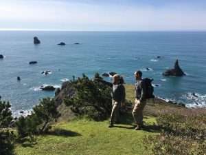
Brandon Tigner and Josh Durham survey the incredible coastal landscape in the Samuel H. Boardman State Scenic Corridor (Photo by Susan Schen)
Why do we assess? When developing a new relationship with a land manager, or even proposing new work with someone we have an existing relationship with, it’s important to be concise, informative, and professional. We endeavor to arrange our assessments to be easy to read, and readily impart our abilities as an organization to meet a project’s needs.
An assessment starts with a conversation with the land managers. It’s important to determine their standards for their trails. Among the things taken into consideration are the degree of expected use and the sorts of users one can expect. Standards are different for a trail open to equestrian use versus hiker only, for example. The park manager for the Sam Boardman determined that the tread width be between 24 and 36 inches, depending on our observed usage. It’s a hiker only trail, which meant the vertical clearance needed only to be eight feet.
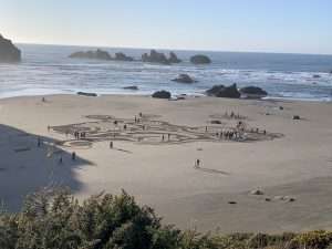
Ephemeral sand art decorates the beach in Bandon. (Photo by Josh Durham)
Once we’ve determined the standards to which we need to hold our trail, we then begin what most would argue is the fun part. We hike. With our GPS apps running, our notebooks and pencils out, and our “trail eyes” open, we move purposefully down the trail, taking GPS tagged pictures and writing notes that correspond. We spend a few moments to a few minutes discussing different options and different tactics.
As an organization, we’ve adopted a “good, better, best” model, in which we offer potential mitigation tactics that a land manager can tailor to their available budget or desire for labor investment in the trail. Perhaps, as in the case of most of the Oregon Coast, there are cultural considerations concerning soil disturbance. This might lead the land manager to select a mitigation tactic that may not be the best long-term choice, but it is something that doesn’t require an archeological consideration that may delay the work indefinitely.
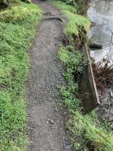
A failing curb structure on the Oregon Coast Trail. (Photo by Josh Durham)
An example of this good/better/best model can be seen in the picture to the right. Here we have an existing curb structure holding up the tread in an area where a stream is causing erosion. An example of a good solution would be to re-install the existing curb structure. The board used currently is held in by metal posts that have sloughed down, causing the plank to move outward. It’s evident, however, that this is a short-term fix. A better solution would be to install a new crib structure, ideally an existing downed log that is longer and ties into either side of the bank. This, in addition to supporting posts, would offer a longer-term solution. The potential issue with this is that in the event of high water, such as during king tides, a curb structure still has the potential to wash out. The best solution would be to install a gabion structure (a gabion is a wire box, akin to chain link fence, that is filled with rock and buried under the tread surface) to shore up the bank and provide support for the tread. Though not immune to erosion, it is substantially more robust than a curb structure.
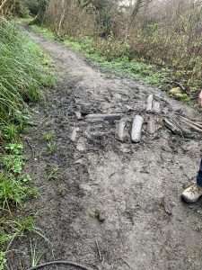
Water pooling on the trail has created a muddy spot. (Photo by Josh Durham)
You can see another example of a trail issue in this picture of a muddy trail (left). This is through a flat section of land, which means there’s nowhere for the water to drain. There’s also no place to realign the trail. We’re really just left with two options here. Good: fill the wet area with two-inch minus rock. This is a very temporary fix, likely only to last until the next high water event, where the material will be washed away. Best: install a turnpike structure that will raise the level of the tread above the flat, wet area and contain the fill material to prevent it from washing away.
Seeing as our goal is to present the manager with a set of options that are as informed as possible, we take all this gathered information back to the office (or coffee shop) to craft a presentable assessment. We create a map that contains our GPS track, with pins to demarcate issues we identified. We create a table listing the various issues, their corresponding GPS coordinates and pin markers, the good/better/best mitigation options, and the length of trail affected. We include pictures of the trail troubles. This is all in succinct and easy to read documents that give the land manager the tools necessary to make a swift and informed decision. All of this allows Trailkeepers of Oregon to get volunteers on the ground, tools in hand, that much more quickly.
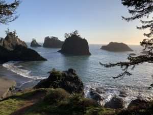
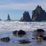
Sea stacks in the waters off the “secret beach,” Samuel H. Boardman State Scenic Corridor. (Photo by Josh Durham)
[EDIT: all in-person TKO activities have been postponed due to the COVID-19 pandemic. Scroll to the bottom of this page to sign up for our email newsletter to receive updates when we’re able to get back out on the trails again!]
Thus an exciting new opportunity is born. Keep your eyes on the event calendar at trailkeepersoforegon.org as we start to post events in the beautiful reaches of the southern coast!